Louisa Cornell
As an author of historical romance who likes to avoid anachronisms whenever possible, an important aspect of setting any story in Regency London is getting the street names properly assigned. Seems an easy enough thing to do. Simply consult a map of London, right? Not exactly. Remember London between 1780 and 1840 was a city that had been built on the ruins of a Roman city of occupation (abandoned in 410 AD,) the ruins and some remains of a medieval city, a city before the Great Fire (before 1666) and then rebuilt after the Great Fire (after 1666,) and a city in the throes of the beginnings of the Industrial Revolution which meant expansion and demolition to reconfigure the city for its new role in the world.
Here is a fascinating video of the growth of London time-lapsed from the Roman era to the present day.
https://www.youtube.com/watch?v=NB5Oz9b84jM
And another video about the population growth from year to year.
https://www.youtube.com/watch?v=xgRxKlpLbpY
In all of this expansion, change, and population growth street names often changed and streets often merged with other streets. Therefore, if one wishes to be completely accurate when placing a street name in one’s fiction it is best to consult a map drawn as close to the date of said fiction as possible. Now that does not mean a writer must find a map for the very month and year in which one’s story is set. These things did not happen overnight. Many streets, alleys, lanes, and other thoroughfares have maintained their names from as early as the Roman era.
Important Caveat:
There are no thoroughfares named road within the Square Mile or heart of London. Lots of streets, alleys, and lanes, but no roads. Likely because that term was not assigned to thoroughfares other than those in the countryside until the 17th century by which time most of the thoroughfares in London had already been established.
Here are a few London street names with a bit about their history and/or where their names were derived.
Broad Sanctuary
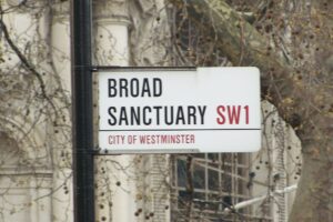
This street in the heart of Westminster is actually the street down which King Charles III passed for his coronation. The street has been so named since the medieval era and was named as it was a place where criminals and refugees could seek sanctuary and avoid arrest.
Abbey Orchard Street
This was where the Benedictine monks of Westminster Abbey raised fruit which they sold at Covent Garden (once called Convent Garden) to supplement the monastery’s income, that is until Henry VIII dissolved the monasteries. The monastery was gone, but the street name remained.
Downing Street
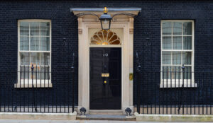
Yes, that Downing Street. Like many of the streets and squares in London it was named after the developer of the street. George Downing was pronounced a “perfidious rogue and doubly perjured traitor” by Samuel Pepys. He was one of Oliver Cromwell’s spymasters, but after the Restoration he sold his secrets to the Crown and managed to keep the property he had acquired thanks to his loyalty to Cromwell.
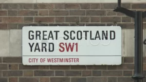
Scotland Yard
This was actually the London residence of the kings of Scotland until the union of the crowns of Scotland and England in 1603.
King’s Cross
Unfortunately, King’s Cross was named after one King George IV. His statue was erected atop a monument there in 1830 and looked down literally on the impoverished neighborhood known as Battle Bridge, the home of thieves, murderers, and a smallpox hospital. They took the statue down in 1845, but the name remains.
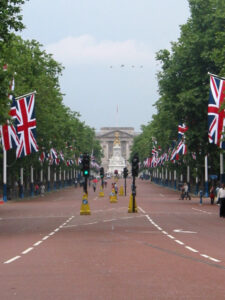
The Mall
This red brick paved road that leads to Buckingham Palace was originally an alley where King Charles II played the game of pall-mall (pronounced pell-mell.) The street next to the alley received the same name.
Birdcage Walk
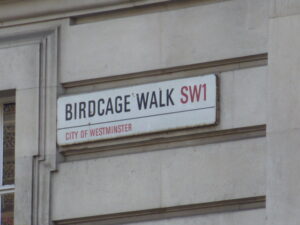
This was a lane built to pass through James I’s aviary. The name stuck. Oddly enough, considering James I’s sexual orientation (either gay or bisexual depending on which biography one reads) this particular lane was used by gay men to stroll for partners during the Regency era.
Piccadilly
In the 17th century a tailor who made his fortune fashioning pickadills – the collars that supported those fashionable ruffs had his house on the street named Pickadilly Hall. It was not meant as a compliment. The street had been known as Portugal Street after King Charles II’s queen. However, by the middle of the 18th century the name Piccadilly was firmly affixed.
Oxford Street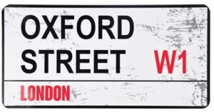
This street was known as Tyburn Way until 1783. That was when the gallows at the end of the street was dismantled. Before then, over the years, 50,000 condemned prisoners were carted down this Tyburn Way to meet their fate at the end of a rope on the western end of this street.
Soho
This neighborhood was once an area of countryside popular for fox hunts conducted by the aristocracy. The area got its name from a form of the hunting cry Tally-ho!
Pudding Lane
Sounds sweet, right? Not so much. This lane was known as early as the medieval era as the route butchers took to carry their pudding – animal entrails – from the meat market down to the Thames water-gate. The Thames, London’s garbage disposal.
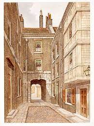
Fleet Street
The name comes from an old Anglo-Saxon word fliotan meaning of the water or water travel. The street follows the route of the river which was rerouted underground to provide a sewer for London in 1766. Since the 19th century Fleet Street has been called the river of ink or street of ink due to its associations with the newspaper industry. I will allow you to draw your own conclusions as to the establishment of newspapers over a river turned into a sewer.
Hanging Sword Alley
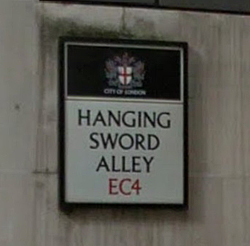
This alley is located just off Fleet Street and was once home to a fencing and sword fighting academy. In the 18th century, however, it became known as Blood Bowl alley after the tavern there that was known as the den of thieves, gamblers, and an assortment of other rogues.
Knightrider Street
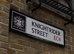
This street lies just south of St. Paul’s Cathedral and likely got its name as it was the route knights took when traveling to Smithfield for jousting tournaments.
Wardrobe Place
From the reign of Edward III until the Great Fire, a building stood on this street where the monarchs of England kept their finest clothes stored. Apparently they needed the extra closet space. There is a plaque outside Number 5 Wardrobe Place that marks the spot where the building that gave the street its name stood.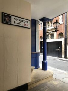
St. Mary Axe
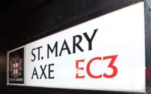
This street was named after a church that was torn down in 1561. There was supposedly a relic held by the church, an axe used by Atilla the Hun to behead 11,0000 virgins who followed St. Ursula. Now the slaughter took place in Cologne, but holy relics tended to travel quite a bit, so who knows. It might have ended up in London
Fetter Lane
This street was known as the site of executions, but for a very sad reason. It comes from the Old English word faitours or fewters which meant idlers or vagrants. The name goes back to the 14th century when the Crown decided to bring in the executioners and hang the vagrants thereby cleaning up the street.
Cockspur Street
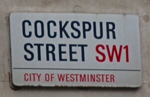
During the Georgian era cock fighting was still a popular sport. This street in the Whitehall area was home to a large cockfighting pit. Cock fighting was not banned in England until 1835. There are a number of locations in London with references to cock fighting in their names.
A couple of resources for you if you want to learn more about London’s street names!
London Place Names by Caroline Taggart
Dictionary of London Street Names by Al Smith
London Street Names by Michael Baker and Hilary Bates Neary
Discovering London Street Names by John Wittich